Part IV
Meantime back to the Air War, "Wild Bill", our Group Commander, had called another urgent and momentous session with Squadron COs and OPs officers. This time the 10th Group had been given the priority operational task of providing beach photography which would give the invading forces a first-hand picture of what would be facing them on "D-Day". After much discussion regarding just how to carry out this vital mission it was finally agreed that it could best be accomplished by flying each sortie "on the deck". The innovation of the low-level "dicing" mission had just become a reality. Yes, the 34th was soon to find itself truly operating in the skies from the ground up.
Before reaching our "low-level" conclusion we had covered a gamut of considerations--most of them involving altitudes of 20,000 feet and below. At best it was generally considered, that all altitudes from the "Deck" to 20,000 would be extremely hazardous. It was our job to select the option which would prove productively successful with the least amount of hazards involved.
Consequently the missions were principally designed with the following profile in mind: (1) To enhance the element of surprise, all missions would be flown just above water level from the British Coast to target area--hence, aircraft would be safely below all enemy radar surveillance and subjected to minimum detection; (2) The tradeoff achieved from cloudless conditions would more than make up for the amount of distortion which would be experienced from the oblique photography taken at such extreme low altitudes and speeds of 300 plus mph; (3) The French Coast from the Cotentin peninsula (Cherbourg) in the South to and including some of the extreme southern Belgian beach frontage to the North was divided into what amounted to relatively short missions. This planning would both lessen the chance of the Germans possibly pinpointing an exact invasion location and allow the pilots to fly in to their target area, get their pictures and escape over the water quickly before the enemy had much opportunity to zero in with small arms and coastal defenses; (4) Each plane would be retrofitted with the installation of right and left side-looking oblique cameras equipped to run continuously with the nose camera, also installed in the oblique position, to insure maximum continuous photo coverage at 300 plus mph speeds; (5) All missions would be flown during time of low tide in order to photograph all under-water obstacles and consequently maximize overall beach photo coverage; (6) And the 30th, 31st and 34th Photo "Recce" Squadrons of the 10th Photo Reconnaissance Group were assigned to fly these coastal missions soonest--most of which were flown during the period of 6-20 May 1944.
In our inventory of aircraft, if I remember correctly, the 34th had one F-5 model "A" that we used for instrument training and local flying. In as much as it was stripped down and not fitted with all the gear necessary for high altitude combat missions this really met our requirements for a fast, light low-altitude aircraft. Just what we wanted, the engineering and camera repair sections worked around-the-clock to ready this bird for its important mission--even the pilots pitched in with a coat or two of wax on the metal surface hoping to pick up an extra naught or two of speed. But as it turned out one of the most important items added at the last minute, but not forgotten, was a relatively small section of bullet-proof glass installed by Lee Wiegand in the front canopy section to protect the pilot.

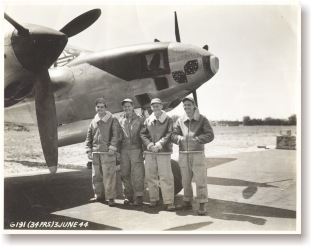
3-June/44 - The crew of "My-Little D-Icer" (left to right) is: John Koziol, Ray Kupski, Matthew Drankwater and Joseph Kopczynski. Taken at Chalgrove, this photo shows the F-5A-3-LO (sn 42-12786) specially outfitted for the Omaha Beach "dicing" mission. Stripped of paint and specially fitted with a forward facing 12" K-17 camera, this is the ship which 2Lt. Garland A. York and 2Lt. Allen R. Keith flew their "dicing" missions. Note the armoured glass in the cockpit -- sans seagull feathers! (Allen Keith) When asked for volunteers all of the original pilots in the squadron did so with the two of us grounded reserving the right to fly the first subsequent dicing missions assigned after being returned to combat flying status. In the drawing of straws Allen Keith and Garland York's names were drawn to fly the first two missions assigned to the 34th.
Lt Keith drew the very heavily defended coastline of Le Harve and vicinity. Small arms and coastal defense caused him little or no trouble but a seagull which couldn't quite clear the area smashing into his canopy and the newly installed bullet-proof glass almost caused his undoing. Keeping his aircraft under control while covered with blood and feathers proved no easy task and left little margin of error at this altitude. Nevertheless he managed to bring both "birds" as well as excellent photography home to complete both a successful and harrowing experience. Thank God for the assist from Wiegand's "little piece of glass". To Garland York, the youngest of the original pilots in the squadron, went the plaudits of all. As the D-Day invasion unfolded it became common knowledge that he had photographed the exact section of the Normandy beaches that the American Forces landed on. He had photographed all of "Omaha" and most of "Utah" beaches. Like similar low-level missions flown up and down the coast Garland had pin-pointed the beach barriers, teller mines attached to imbedded posts under water during high water conditions and other coastal defenses in minute detail as well as scattering his share of German soldiers working here and there along the beach. He also was in and out with his "great" photography before the German "beach bums" had time to shake off their surprise and grab their weapons.
Although the Presidential Unit Citation and the many commendations received from the highest ranking military figures all agreed that the information provided by these photographs saved countless allied ground and naval invasion personnel it was the comments from one of our own (adopted, second generation) that was really the most meaningful, personally, to the Thirty Fourth.
Lt. Ray Lanterman (the kid brother to our own beloved Charlie Lanterman) as a member of the 146th Combat Engineers "hit his section of Omaha Beach" at "H-Hour M-minute" (lowest tide) ahead of the first wave 6 June 1944. It was his and his comrade's mission to clear a path through the beach obstacles for the following landing barges and invading ground forces. They did just that.

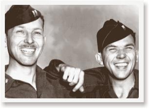
30-April 1944 - On leave from his unit, Ray Lanterman (right) stopped by to visit his brother Charlie (left) while the 34th was stationed at Chalgrove, England. (Charlie Lanterman) Ray reported that two weeks before the invasion he and his fellow engineers were isolated in a fenced enclosure and briefed extremely thoroughly on the appearance of that part of Normandy Beach they'd be landing on. For the briefing they had lots of both low and high altitude aerial photography some of which he had seen before when he had visited brother Charlie and the 34th earlier at Chalgrove. There was also an extremely accurate scale mock-up of Omaha Beach in its entirety complete with natural features, trees, houses, other buildings and such German military installations as were known to be there to include an extremely detailed accounting of all beach obstacles. The landing site was memorized and the obstacles in the photographs confronting them were studied over and over again until they knew it all backwards and forwards. Later, when they did land they saw just how accurate the model had been. The Invasion Coast looked just like it--down to the last detail. "Thanks, gentlemen of the 34th, for your important contribution without which our mission could well have been a failure." (After a month or so of healing and recuperation and wearing a Distinguished Service Cross beside his Purple Heart, Ray Lanterman was reassigned to duty on the continent--this time "inland" and "behind Patton's forces").
